
Creekside at Country Club Estates A Few Favorite Things To Do
Explore WNC
Visit local favorites all around Haywood County.
Made up of the five towns of Canton, Clyde, Lake Junaluska, Maggie Valley, and Waynesville, Haywood County offers affordable and exciting adventures that everyone can enjoy.
Not sure what to do in Haywood County? How about relaxing, enjoying outdoor adventures, and indulging in great food and drink, all while soaking in the scenic beauty that our mountain towns have to offer?
Or, perhaps you would enjoy winding down in the evening at the local craft breweries and restaurants and sampling the best of the best regional food and craft beer.
Haywood County has everything needed to plan a perfect grown-up style getaway, no matter the time of year, so come and explore this little slice of heaven in the mountains!
Nature At Its Best: The Western North Carolina mountains are home to thousands of miles of hiking trails perfect for any skill level. Are you looking for a trail that weaves through lush forests, leads to a scenic overlook, or ends with a stunning waterfall? Maybe you want to walk a section of the famed Appalachian Trail? Haywood County has all of that and much more.
My favorite area trails include:
• Purchase Knob– a 4.1-mile round trip hike in the Great Smoky Mountains National Park
• Hemphill Bald– a 13.7-mile loop, but just 4.7 miles to the bald
• Mount Sterling- a strenuous 5.4-mile round trip from Sterling Gap
If hiking isn’t your thing or you just want to cool off, rent a canoe, kayak, or paddleboard and discover the beauty of Lake Junaluska from your chosen craft.
If you’re looking for a thrilling whitewater rafting experience, several outfitters are within an hour’s drive or less and many of them also offer ziplining adventures where you can elevate your day while zipping through the trees.
Rule the Road: There’s no lack of curves when it comes to exciting and scenic mountain driving routes. The Blue Ridge Parkway pulls out all the stops as it comes to an end in Haywood County with more views, more elevation, and more overlooks than any other stretch of the 469-mile long Parkway. With four entrances within the county, it's easy to hop on and hop off the Parkway at convenient intervals.
A Hearty Appetite: Throughout Haywood County, visitors can enjoy just about every type of cuisine imaginable.
Finger-licking good North Carolina barbecue? Yes, we have that! (check out Haywood Smokehouse in Waynesville) How about authentic Italian pizza? Yep, we have that too! (Brickhouse Burgers and Pizza in Maggie Valley.)
Other foods are plentiful and easy to find so don't worry if you prefer something else.
Of course, every good meal deserves an equally good beverage, so be sure and check out the three local breweries.
After a day of exploring, drop in for foot-tapping music and sample some local craft brew creations from Bearwaters Brewing Company, Boojum Brewing Company, and Frog Level Brewing Co.
Brews On Tap: Everyone knows that pristine mountain water makes for great craft beer and these Haywood County breweries create delectable local flavors that are aptly named after area landmarks.
• Located along the banks of Jonathan Creek in Maggie Valley, and the Pigeon River in Canton, Bearwaters Brewing Company not only brews hand-crafted flavor varieties, they have partnered with Pigeon River Outfitters where visitors can enjoy a 2-hour long tube float that conveniently ends at the brewery. After working up an appetite on the river, grab a burger and more on site and enjoy the outdoor patio for fun and pet-friendly gatherings.
• Boojum Brewing Company features a fun bar tucked away right below the Waynesville taproom. The Gem serves Boojum beer, wine, and mixed cocktails and features space for hanging out and playing bar games like pool, darts, shuffleboard and foosball. The Gemstone Kitchen serves up delicious tacos, quesadillas, nachos and snacks after 7:00 pm six days a week. The Gem is for visitors aged 21 and up and is perfect for vacation fun. If you have little ones, head upstairs and hang out with them in the upper level taproom.
• Every day is a great day for a beer by the creek and that’s exactly what you get at Frog Level Brewing Company where you can sample some of the smoothest craft beer to ever pass your lips! Relish the bite from a refreshing IPA, savor the smoky darkness of a Scotch Ale, or choose a brew somewhere in between. Order a pint to enjoy in the tasting room or get a croaker (2 pints) or a growler (4 pints) to take with you. If you’re hungry, order a pizza or burger from the Canteen and enjoy it inside, or on the back deck overlooking the adjacent creek. Enjoy live music on the outdoor stage to round out your froggy experience.
108 habitants recommandent
Maggie Valley
Made up of the five towns of Canton, Clyde, Lake Junaluska, Maggie Valley, and Waynesville, Haywood County offers affordable and exciting adventures that everyone can enjoy.
Not sure what to do in Haywood County? How about relaxing, enjoying outdoor adventures, and indulging in great food and drink, all while soaking in the scenic beauty that our mountain towns have to offer?
Or, perhaps you would enjoy winding down in the evening at the local craft breweries and restaurants and sampling the best of the best regional food and craft beer.
Haywood County has everything needed to plan a perfect grown-up style getaway, no matter the time of year, so come and explore this little slice of heaven in the mountains!
Nature At Its Best: The Western North Carolina mountains are home to thousands of miles of hiking trails perfect for any skill level. Are you looking for a trail that weaves through lush forests, leads to a scenic overlook, or ends with a stunning waterfall? Maybe you want to walk a section of the famed Appalachian Trail? Haywood County has all of that and much more.
My favorite area trails include:
• Purchase Knob– a 4.1-mile round trip hike in the Great Smoky Mountains National Park
• Hemphill Bald– a 13.7-mile loop, but just 4.7 miles to the bald
• Mount Sterling- a strenuous 5.4-mile round trip from Sterling Gap
If hiking isn’t your thing or you just want to cool off, rent a canoe, kayak, or paddleboard and discover the beauty of Lake Junaluska from your chosen craft.
If you’re looking for a thrilling whitewater rafting experience, several outfitters are within an hour’s drive or less and many of them also offer ziplining adventures where you can elevate your day while zipping through the trees.
Rule the Road: There’s no lack of curves when it comes to exciting and scenic mountain driving routes. The Blue Ridge Parkway pulls out all the stops as it comes to an end in Haywood County with more views, more elevation, and more overlooks than any other stretch of the 469-mile long Parkway. With four entrances within the county, it's easy to hop on and hop off the Parkway at convenient intervals.
A Hearty Appetite: Throughout Haywood County, visitors can enjoy just about every type of cuisine imaginable.
Finger-licking good North Carolina barbecue? Yes, we have that! (check out Haywood Smokehouse in Waynesville) How about authentic Italian pizza? Yep, we have that too! (Brickhouse Burgers and Pizza in Maggie Valley.)
Other foods are plentiful and easy to find so don't worry if you prefer something else.
Of course, every good meal deserves an equally good beverage, so be sure and check out the three local breweries.
After a day of exploring, drop in for foot-tapping music and sample some local craft brew creations from Bearwaters Brewing Company, Boojum Brewing Company, and Frog Level Brewing Co.
Brews On Tap: Everyone knows that pristine mountain water makes for great craft beer and these Haywood County breweries create delectable local flavors that are aptly named after area landmarks.
• Located along the banks of Jonathan Creek in Maggie Valley, and the Pigeon River in Canton, Bearwaters Brewing Company not only brews hand-crafted flavor varieties, they have partnered with Pigeon River Outfitters where visitors can enjoy a 2-hour long tube float that conveniently ends at the brewery. After working up an appetite on the river, grab a burger and more on site and enjoy the outdoor patio for fun and pet-friendly gatherings.
• Boojum Brewing Company features a fun bar tucked away right below the Waynesville taproom. The Gem serves Boojum beer, wine, and mixed cocktails and features space for hanging out and playing bar games like pool, darts, shuffleboard and foosball. The Gemstone Kitchen serves up delicious tacos, quesadillas, nachos and snacks after 7:00 pm six days a week. The Gem is for visitors aged 21 and up and is perfect for vacation fun. If you have little ones, head upstairs and hang out with them in the upper level taproom.
• Every day is a great day for a beer by the creek and that’s exactly what you get at Frog Level Brewing Company where you can sample some of the smoothest craft beer to ever pass your lips! Relish the bite from a refreshing IPA, savor the smoky darkness of a Scotch Ale, or choose a brew somewhere in between. Order a pint to enjoy in the tasting room or get a croaker (2 pints) or a growler (4 pints) to take with you. If you’re hungry, order a pizza or burger from the Canteen and enjoy it inside, or on the back deck overlooking the adjacent creek. Enjoy live music on the outdoor stage to round out your froggy experience.
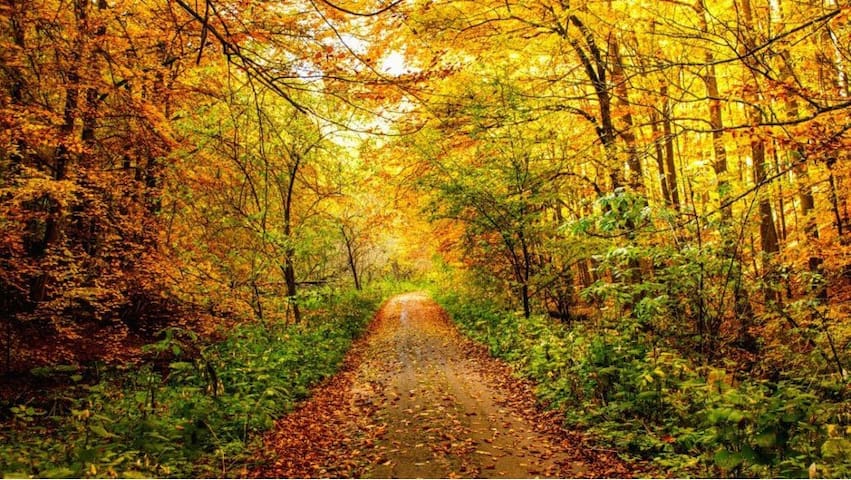
Visit Maggie Valley, North Carolina! Fall foliage colors in and around the area produce some of the most beautiful views you’ll see anywhere in the world, so get ready to make plans to head toward Western North Carolina this Fall.
Maggie Valley is adjacent to both the Blue Ridge Parkway and the Great Smoky Mountains National Park, making it the perfect location to get your Fall color on!
Undoubtedly, the mountains are beautiful every season of the year, but there's something very special about Maggie Valley when it's surrounded by Fall's cool and crisp air.
The annual color show of vibrant reds, oranges, and yellows make Maggie Valley one of the best places to participate in annual leaf peeper fun.
When?
Only Mother Nature truly knows when the prime Fall color viewing time begins, but I’m here to help you out as much as I can!
Blue Ridge Parkway: Spotty color changes begin at elevations above 6,000 feet during the last week of September. From downtown Maggie Valley, you can literally be on the Blue Ridge Parkway in about ten minutes, so taking a leisurely drive on the famous BRP is a good place to start.
From the Maggie Valley parkway entrance, you can drive toward Cherokee and stop at any number of nice overlooks, but the altitude and views aren’t quite as remarkable as heading in the opposite direction toward Asheville.
If you choose the Asheville option, you’ll travel through the highest elevation point on the parkway and enjoy numerous scenic overlooks that offer long-distance views, all dappled in delightful Fall color.
Cataloochee Valley: This one is definitely a favorite! If you prefer a remote, off the beaten path location, head to Cataloochee Valley in Great Smoky Mountains National Park.
Cataloochee Valley is famous for its historic structures and is a much sought-after location for elk viewing.
Cataloochee Valley’s elevation is 2,600 feet, so Fall color generally peaks in mid to late October. For a real treat, the elk are in the midst of rut, the annual mating season for these stately animals.
During rut, male elk make bugling calls to challenge other bulls and attract female elk. Amazingly, bull elk bugling calls may be heard more than a mile away.
Rut occurs from mid-September to mid-October so it’s the perfect time to catch the leaf peeper views as well as hear the mighty bugle sounds.
The Swag: When I first moved to Maggie Valley, I heard many locals talking about The Swag. Back then, I envisioned something else entirely than what The Swag actually is.
The Swag is a remote mountain top Inn and restaurant, nestled on the edge of the Great Smoky Mountains National Park, and at 5,000 feet in elevation, it sits between several peaks over 6,000 feet tall. The best leaf color here should be around the first to second week of October.
There are two routes to get to The Swag, the first being the most direct – booking reservations for one of their awesome picnic lunches. With this option you will gain access to their gate and entry road that takes visitors up to The Swag itself.
The Swag can also be accessed via the Cataloochee Divide and Hemphill Bald trails, which will take you right by The Swag. That’s how I would get there!
Pro Tip: With the picnic lunch reservation, you’ll enjoy a gourmet lunch served at a beautiful mountain overlook with outstanding high elevation views. Book early so you aren’t disappointed!
Cataloochee Ranch: When colors are at their peak in mid to late October, there’s nothing quite like a mountain top horseback ride in the Smoky Mountains during the Fall. If you fancy a leisurely mountain-top ride atop a gentle horse, Cataloochee Ranch is the place to be!
Located at the top of Fie Top Road in Maggie Valley, the Ranch is located right next to the Cataloochee Ski Area. At the Ranch, visitors enjoy guided horseback riding, and many other outdoor activity opportunities.
Choose from a high elevation horseback ride over Hemphill Bald, which provides stunning views, especially in the Fall when colors are peaking.
Pro Tip:Advance reservations required for all horseback rides. Minimum age limit: 8 years old; Minimum weight limit: 55 lbs.; Maximum weight limit: 225 lbs.
Purchase Knob: As part of the Great Smoky Mountains National Park, this knob is a 5,000-foot-tall bald near Maggie Valley that provides stunning 360-degree long distance views from the Science Center located at the top. Peak views are typically early to mid October.
This is a beloved hike for many of my local Maggie Valley friends and they always return from hiking to Purchase Knob raving about how great it is!
During the Fall, the views of Great Smoky Mountains National Park to the west, and the Balsam Mountains to the east are the best they can be.
Pro Tip:While the gate from Hemphill Rd./Purchase Rd. is sometimes open, you should not drive further up the road unless you make arrangements with the Appalachian Highlands Science Learning Center.The best option is to park at the pull-off areas near the gate and walk up.
Drive Heintooga Round Bottom Road: For a delightful Great Smoky Mountains National Park scenic side trip, drive to Balsam Mountain via Heintooga Ridge Road, which begins at Blue Ridge Parkway Milepost 458.2, just 11 miles from the southern end of the Parkway.
This will take you to Heintooga Round Bottom Road, where you can begin a 24-mile perfect road less traveled scenic mountain drive from the Maggie Valleyarea to Cherokee, North Carolina.
I drove this route just a few months ago and loved it! Since this road starts at over 5,000 feet and drops in elevation until reaching Cherokee, NC, peak leaf color times will vary from very early to late October.
Pro Tip: Plan your drive for mid October because Heintooga Ridge Road is typically open from late May through October, but could close due to weather events before or after those dates.
Experiencing any one of these leaf peeper options will lead to great Fall color viewing opportunities in and around the Maggie Valley, North Carolina area.
I hope you enjoy these hand picked favorites for viewing our beautiful Fall foliage.
50 habitants recommandent
Cataloochee
Visit Maggie Valley, North Carolina! Fall foliage colors in and around the area produce some of the most beautiful views you’ll see anywhere in the world, so get ready to make plans to head toward Western North Carolina this Fall.
Maggie Valley is adjacent to both the Blue Ridge Parkway and the Great Smoky Mountains National Park, making it the perfect location to get your Fall color on!
Undoubtedly, the mountains are beautiful every season of the year, but there's something very special about Maggie Valley when it's surrounded by Fall's cool and crisp air.
The annual color show of vibrant reds, oranges, and yellows make Maggie Valley one of the best places to participate in annual leaf peeper fun.
When?
Only Mother Nature truly knows when the prime Fall color viewing time begins, but I’m here to help you out as much as I can!
Blue Ridge Parkway: Spotty color changes begin at elevations above 6,000 feet during the last week of September. From downtown Maggie Valley, you can literally be on the Blue Ridge Parkway in about ten minutes, so taking a leisurely drive on the famous BRP is a good place to start.
From the Maggie Valley parkway entrance, you can drive toward Cherokee and stop at any number of nice overlooks, but the altitude and views aren’t quite as remarkable as heading in the opposite direction toward Asheville.
If you choose the Asheville option, you’ll travel through the highest elevation point on the parkway and enjoy numerous scenic overlooks that offer long-distance views, all dappled in delightful Fall color.
Cataloochee Valley: This one is definitely a favorite! If you prefer a remote, off the beaten path location, head to Cataloochee Valley in Great Smoky Mountains National Park.
Cataloochee Valley is famous for its historic structures and is a much sought-after location for elk viewing.
Cataloochee Valley’s elevation is 2,600 feet, so Fall color generally peaks in mid to late October. For a real treat, the elk are in the midst of rut, the annual mating season for these stately animals.
During rut, male elk make bugling calls to challenge other bulls and attract female elk. Amazingly, bull elk bugling calls may be heard more than a mile away.
Rut occurs from mid-September to mid-October so it’s the perfect time to catch the leaf peeper views as well as hear the mighty bugle sounds.
The Swag: When I first moved to Maggie Valley, I heard many locals talking about The Swag. Back then, I envisioned something else entirely than what The Swag actually is.
The Swag is a remote mountain top Inn and restaurant, nestled on the edge of the Great Smoky Mountains National Park, and at 5,000 feet in elevation, it sits between several peaks over 6,000 feet tall. The best leaf color here should be around the first to second week of October.
There are two routes to get to The Swag, the first being the most direct – booking reservations for one of their awesome picnic lunches. With this option you will gain access to their gate and entry road that takes visitors up to The Swag itself.
The Swag can also be accessed via the Cataloochee Divide and Hemphill Bald trails, which will take you right by The Swag. That’s how I would get there!
Pro Tip: With the picnic lunch reservation, you’ll enjoy a gourmet lunch served at a beautiful mountain overlook with outstanding high elevation views. Book early so you aren’t disappointed!
Cataloochee Ranch: When colors are at their peak in mid to late October, there’s nothing quite like a mountain top horseback ride in the Smoky Mountains during the Fall. If you fancy a leisurely mountain-top ride atop a gentle horse, Cataloochee Ranch is the place to be!
Located at the top of Fie Top Road in Maggie Valley, the Ranch is located right next to the Cataloochee Ski Area. At the Ranch, visitors enjoy guided horseback riding, and many other outdoor activity opportunities.
Choose from a high elevation horseback ride over Hemphill Bald, which provides stunning views, especially in the Fall when colors are peaking.
Pro Tip:Advance reservations required for all horseback rides. Minimum age limit: 8 years old; Minimum weight limit: 55 lbs.; Maximum weight limit: 225 lbs.
Purchase Knob: As part of the Great Smoky Mountains National Park, this knob is a 5,000-foot-tall bald near Maggie Valley that provides stunning 360-degree long distance views from the Science Center located at the top. Peak views are typically early to mid October.
This is a beloved hike for many of my local Maggie Valley friends and they always return from hiking to Purchase Knob raving about how great it is!
During the Fall, the views of Great Smoky Mountains National Park to the west, and the Balsam Mountains to the east are the best they can be.
Pro Tip:While the gate from Hemphill Rd./Purchase Rd. is sometimes open, you should not drive further up the road unless you make arrangements with the Appalachian Highlands Science Learning Center.The best option is to park at the pull-off areas near the gate and walk up.
Drive Heintooga Round Bottom Road: For a delightful Great Smoky Mountains National Park scenic side trip, drive to Balsam Mountain via Heintooga Ridge Road, which begins at Blue Ridge Parkway Milepost 458.2, just 11 miles from the southern end of the Parkway.
This will take you to Heintooga Round Bottom Road, where you can begin a 24-mile perfect road less traveled scenic mountain drive from the Maggie Valleyarea to Cherokee, North Carolina.
I drove this route just a few months ago and loved it! Since this road starts at over 5,000 feet and drops in elevation until reaching Cherokee, NC, peak leaf color times will vary from very early to late October.
Pro Tip: Plan your drive for mid October because Heintooga Ridge Road is typically open from late May through October, but could close due to weather events before or after those dates.
Experiencing any one of these leaf peeper options will lead to great Fall color viewing opportunities in and around the Maggie Valley, North Carolina area.
I hope you enjoy these hand picked favorites for viewing our beautiful Fall foliage.
Sightseeing 441 (Newfound Gap Road)
Instagram worthy photo ops listed by mile marker
For photographers of all skill levels, the Great Smoky Mountains National Park is one of the most beautiful and photogenic parks in the United States. Ridge upon ridge of natural beauty straddles the border between North Carolina and Tennessee and encompasses over 522,000 acres of forested wonderland.
You’ll find many stunning long-range mountain views, tranquil valleys and bubbling streams that make this park one of the best locations for Instagram worthy landscape photography.
Read on to find the best photo op spots for sunrise and sunset photography on the North Carolina side of the park, along with similarly great photo opportunities along Newfound Gap Road.
The locations are noted via odometer mileage distances from the Cherokee entrance of the park (US 441/Newfound Gap Road), using the Great Smoky Mountains entrance sign as a starting point.
The Best Instagrammable Photo Spots in NC: At 0.9 tenths of a mile, look to the right for the entrance to the Oconaluftee Visitor Center. There is a good chance you’ll see elk grazing in the large field during certain times of the day, typically around dusk and dawn. If you’re lucky, the elk will occasionally visit during mid to late afternoon as well.
At 1.6 miles, look for the left turn into Mingus Mill. There are some excellent photo opportunities here. Park near the bathroom building and pick up the short trail to the mill just to the right of the restrooms.
At 4.1 miles, turn right into the Smokemont area. If you have time, trails in the area will wind through very pretty terrain with streams, mountain laurel, rhododendron and other wild flowers.
For those not hiking, park your car in the lot straight ahead from the right turn and tour the Smokemont Church. Spring and fall are great times to get photos of emerging and colorful foliage around the church and steeple.
At 7.9 miles, look for pull off parking along both sides of the road. Here you’ll find the trailhead for the Kephart Prong Trail, which starts out as a bridge over the Oconaluftee River.
Capture a long view of the river from the bridge looking to the right. Or climb down the gentle embankment on the left side and photograph the bridge crossing the river.
US 441/Newfound Gap Road continues to climb to the higher elevations, where long-range views of mountain ridges are quite plentiful. Most of these overlooks and parking areas will be on the left side so stop and enjoy the views if you have time.
Long range views can be seen from the Webb Overlook at 13.4 miles. At the left end of the parking area, there are beautiful views of mountain ridges with a couple of distinct trees in the foreground.
The next two overlooks are at 14.0 and 14.2, both with equally beautiful views. The first overlook has space for just a couple of cars. Look for the walkway to the right that follows alongside the road and walk out to the end. This is one of the most photogenic spots in the park for long-range views. The next overlook is just a short distance away, has more parking, and offers the same view from a slightly different angle.
At 14.7 miles, this overlook has long-range views that are gorgeous in every season of the year. This is also the trailhead for the high elevation portion of the Deep Creek Trail with long-range views looking out to the left.
At 15.6 miles, you’ll arrive at the best spot for sunrise photos – Oconaluftee Valley Overlook. When you approach this overlook, a large parking lot is on the left, however the view will be to your right. There is plenty of parking here, but photographers will arrive long before daybreak to get prime spots for sunrise photography.
At 16.2 milesis the left turn onto Clingmans Dome Road. Follow the 7-mile-long road to the large parking area at the end. This is a great location for sunset photography, second only to Morton Overlook (see below). You don’t have to climb to the Clingmans Dome observation towerto get a great sunset photo since you can easily get marvelous views from the parking lot. The best vantage point will be at the farthest end of the parking lot where beautiful sunrise images can also be captured.
Bonus Instagrammable spot: Immediately after turning onto Clingmans Dome Road there will be a pull off large enough for a couple of cars. Park here and walk along the grassy shoulder for about 100 yards. Where the road becomes a bridge, walk down the hill for about 20 feet and you will come to the Hiker’s Tunnel. This is an old portion of the Appalachian Trail before it was rerouted some distance away. Photo ops of the tunnel can be taken from either side.
At 16.3 miles, not counting any of the miles on Clingmans Dome Road, make the right turn into the Newfound Gapparking area. This is usually crowded, especially during peak tourist season. Here you’ll find the NC/TN state line and see where the Appalachian Trail crosses. For the best photo opportunities, step to the furthest right side of the parking lot and look south along the ridges that define US 441/Newfound Gap Road.
Tennessee Side Photo Spots
At 17.1 miles, Morton Overlook is considered the best place in the park for sunset views. At certain times of year, the sun will align itself between the peaks as it goes down, including the month of May. Parking spots and prime viewing locations fill up fast so plan to arrive at least an hour ahead of time, especially on weekends or during peak tourist seasons.
If you continue north on Us 441/Newfound Gap Road, you’ll find the trailheads for Alum Cave and Chimney Tops, as well as several other low elevation overlooks as you approach the Gatlinburg, TN area.
Turn left on Little River Road to reach the Elkmont, Tremont, and Cades Cove areas. Or turn right in Gatlinburg and look for the Roaring Fork Nature Trail for beautiful streams and historic building photo ops.
Newfound Gap
For photographers of all skill levels, the Great Smoky Mountains National Park is one of the most beautiful and photogenic parks in the United States. Ridge upon ridge of natural beauty straddles the border between North Carolina and Tennessee and encompasses over 522,000 acres of forested wonderland.
You’ll find many stunning long-range mountain views, tranquil valleys and bubbling streams that make this park one of the best locations for Instagram worthy landscape photography.
Read on to find the best photo op spots for sunrise and sunset photography on the North Carolina side of the park, along with similarly great photo opportunities along Newfound Gap Road.
The locations are noted via odometer mileage distances from the Cherokee entrance of the park (US 441/Newfound Gap Road), using the Great Smoky Mountains entrance sign as a starting point.
The Best Instagrammable Photo Spots in NC: At 0.9 tenths of a mile, look to the right for the entrance to the Oconaluftee Visitor Center. There is a good chance you’ll see elk grazing in the large field during certain times of the day, typically around dusk and dawn. If you’re lucky, the elk will occasionally visit during mid to late afternoon as well.
At 1.6 miles, look for the left turn into Mingus Mill. There are some excellent photo opportunities here. Park near the bathroom building and pick up the short trail to the mill just to the right of the restrooms.
At 4.1 miles, turn right into the Smokemont area. If you have time, trails in the area will wind through very pretty terrain with streams, mountain laurel, rhododendron and other wild flowers.
For those not hiking, park your car in the lot straight ahead from the right turn and tour the Smokemont Church. Spring and fall are great times to get photos of emerging and colorful foliage around the church and steeple.
At 7.9 miles, look for pull off parking along both sides of the road. Here you’ll find the trailhead for the Kephart Prong Trail, which starts out as a bridge over the Oconaluftee River.
Capture a long view of the river from the bridge looking to the right. Or climb down the gentle embankment on the left side and photograph the bridge crossing the river.
US 441/Newfound Gap Road continues to climb to the higher elevations, where long-range views of mountain ridges are quite plentiful. Most of these overlooks and parking areas will be on the left side so stop and enjoy the views if you have time.
Long range views can be seen from the Webb Overlook at 13.4 miles. At the left end of the parking area, there are beautiful views of mountain ridges with a couple of distinct trees in the foreground.
The next two overlooks are at 14.0 and 14.2, both with equally beautiful views. The first overlook has space for just a couple of cars. Look for the walkway to the right that follows alongside the road and walk out to the end. This is one of the most photogenic spots in the park for long-range views. The next overlook is just a short distance away, has more parking, and offers the same view from a slightly different angle.
At 14.7 miles, this overlook has long-range views that are gorgeous in every season of the year. This is also the trailhead for the high elevation portion of the Deep Creek Trail with long-range views looking out to the left.
At 15.6 miles, you’ll arrive at the best spot for sunrise photos – Oconaluftee Valley Overlook. When you approach this overlook, a large parking lot is on the left, however the view will be to your right. There is plenty of parking here, but photographers will arrive long before daybreak to get prime spots for sunrise photography.
At 16.2 milesis the left turn onto Clingmans Dome Road. Follow the 7-mile-long road to the large parking area at the end. This is a great location for sunset photography, second only to Morton Overlook (see below). You don’t have to climb to the Clingmans Dome observation towerto get a great sunset photo since you can easily get marvelous views from the parking lot. The best vantage point will be at the farthest end of the parking lot where beautiful sunrise images can also be captured.
Bonus Instagrammable spot: Immediately after turning onto Clingmans Dome Road there will be a pull off large enough for a couple of cars. Park here and walk along the grassy shoulder for about 100 yards. Where the road becomes a bridge, walk down the hill for about 20 feet and you will come to the Hiker’s Tunnel. This is an old portion of the Appalachian Trail before it was rerouted some distance away. Photo ops of the tunnel can be taken from either side.
At 16.3 miles, not counting any of the miles on Clingmans Dome Road, make the right turn into the Newfound Gapparking area. This is usually crowded, especially during peak tourist season. Here you’ll find the NC/TN state line and see where the Appalachian Trail crosses. For the best photo opportunities, step to the furthest right side of the parking lot and look south along the ridges that define US 441/Newfound Gap Road.
Tennessee Side Photo Spots
At 17.1 miles, Morton Overlook is considered the best place in the park for sunset views. At certain times of year, the sun will align itself between the peaks as it goes down, including the month of May. Parking spots and prime viewing locations fill up fast so plan to arrive at least an hour ahead of time, especially on weekends or during peak tourist seasons.
If you continue north on Us 441/Newfound Gap Road, you’ll find the trailheads for Alum Cave and Chimney Tops, as well as several other low elevation overlooks as you approach the Gatlinburg, TN area.
Turn left on Little River Road to reach the Elkmont, Tremont, and Cades Cove areas. Or turn right in Gatlinburg and look for the Roaring Fork Nature Trail for beautiful streams and historic building photo ops.